At the end of August we hiked Winchester Mountain with friends who had recently moved to Washington and family members of theirs who were seeing the Cascades for the first time.
Winchester Mountain is in the Mount Baker Wilderness area of Mount Baker-Snoqualmie National Forest and the hike to the top, though not strenuous, is one of the most spectacular in the Cascades.
We began our hike near Twin Lakes and followed the trail up the south side of the mountain enjoying the wildflowers and the views of the lakes as we climbed higher and higher above them.
The weather was mixed with occasional sunshine and a lot of clouds, but we had no rain. The clouds obscured the peaks to the south however, and only the lower slopes of Mount Baker were visible.
Though near the end of August there were still a lot of wildflowers blooming, Fireweed, Saxifrage, Purple Monkeyflower and Penstemon and the higher we climbed the more flowers we saw.
On one of the shoulders of Winchester Mountain we had our first view of Mount Larrabee, the Border Peaks (only just visible) and High Pass, visible again when we rounded the mountain.
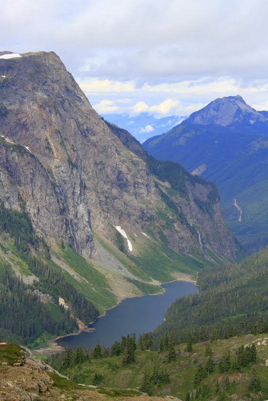
As we crossed a saddle on the southwest corner of the mountain and began to round the west side of the mountain we got our first views of Tomyhoi Peak and Tomyhoi Lake far below.
We stopped there for pictures of the Subalpine Firs with their beautiful purple cones and though we had been eating wild blueberries all the way found them in abundance on this part of the trail.
Here again Mount Larrabee and the Border Peaks began to come into view and we stopped often for pictures both of the peaks crowned with clouds and of the wildflowers.
Reaching the top we enjoyed the view, took pictures of the restored fire lookout both inside and out and now a camping spot for hikers before heading back down to the car and home.
Coming down we enjoyed the same views and many more wildflowers, but the weather was threatening and we did not want to be caught in the rain, so we did not linger.