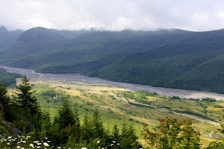
We had a grandson staying with us for five weeks in June and July and took him and a friend to see some of the sights here in Washington, including a brief visit to Mount St. Helens. We went to the Johnson Observatory on the north and west side of the volcano, but were disappointed that the day was cloudy and that we were unable to see very much. He did see the video of the eruption at the visitors center and was able to see the results of the eruption which are still very much visible. Here are a few pictures from that trip.
Toutle River Valley
(this is the main mud flow area)
The last time we were at Mount St. Helens was 2009 when we came in from the east side and ended up at Windy Ridge. We had intended to backpack in for a couple of days but it was very hot and we changed our plans, staying only for part of day and visiting only the Windy Ridge area.Both then and now the devastation caused by the eruption are simply unbelievable. These pictures show something of what we saw on that visit, but from a very different perspective. They were taken four years ago and were taken especially from the east.
The Volcano and Spirit Lake
Floating Trees from the Blast in Spirit Lake
Main Blast Area
Mount Adams from Mount St. Helens
Miner's Car
The sign near this car reads: "This car was tossed about like a toy, rolled from across the road where it had been parked. Owners of the car were in their cabin at a nearby mine and were killed when Mount St. Helens erupted. One source says that "fifty-seven people in all were killed, 250 homes, 47 bridges, 15 miles (24 km) of railways, and 185 miles (298 km) of highway were destroyed and the elevation of the mountain's summit was reduced from 9,677 ft (2,950 m) to 8,365 ft (2,550 m), replacing it with a 1 mile (1.6 km) wide horseshoe-shaped crater."
At the time we visited Mount St. Helens in 2009 I wrote this: Visiting the volcano was quite an experience for us. The eruption had taken place nearly 30 years ago in 1980 and we expected to see the vegetation in the blast area well on the way to recovery, but found instead that the area around the volcano is still a barren wilderness. Even at the outer edges of the blast area, six to eight miles from the volcano there are few trees growing and nearer the volcano in the area shown in this picture there are areas that are still bare of vegetation and completely treeless. Farther from the volcano the trees are still laid out in neat rows just as they were felled by the blast, but near the volcano the trees are completely gone, in most cases not even the stumps remaining. Spirit Lake, too, is still partly filled with floating trunks of trees that were blown into the lake by the eruption. As for the volcano itself, though it lost 1200 feet of elevation in the eruption it is still an impressive mountain, looming over the surrounding area. In this photo the side of the mountain that collapsed during the eruption can be seen as well as steam from some of the vents on the mountain and the new cone that is building within the crater.


4 comments:
You need to climb Monitor Ridge to the crater edge. No flowers along the way, but in Late July thru September the clear day view is something to experience
Great photos! I don't remember ever visiting Mt. St. Helens with you at all. Did we go when I lived in Lynden? If not, might be a trip we have to make sometime. ~ Rose
We've been there twice, but neither time with you. Mom and I went once in 2009 intending to hike on the east side but it was beastly hot and we gave it up. We went again this summer with Sean and Jacob, but were there only for a short time. Didn't want the boys to get antsy.
That is one we must do. Maybe in a few weeks.
Post a Comment